AI Earth 设置了研究区域,这里也筛选了,为什么显示全球的图像啊?!
AI Earth 设置了研究区域,这里也筛选了.filterBounds(feature_collection) \,为什么显示全球的图像啊?
aie.Authenticate()
aie.Initialize()
将reducer应用到影像集合中,执行对应的reduce操作。
指定需要检索的区域
feature_collection = aie.FeatureCollection('China_Province') \
.filter(aie.Filter.eq('province', '四川省'))
指定检索数据集,可设置检索的空间和时间范围,以及属性过滤条件(如云量过滤等)
image_collection = aie.ImageCollection('MODIS_MOD17A2H_006') \
.filterBounds(feature_collection) \
.filterDate('2018-10-01', '2018-10-31') \
reduce运算,指定一个Reducer
reduce_image = image_collection.reduce(aie.Reducer.mean())
print(reduce_image.getInfo())
结果预览
map = aie.Map(
center=reduce_image.getCenter(),
height=800,
zoom=7
)
vis_params = {
'bands': ['Gpp', 'PsnNet', 'Psn_QC'],
'min': 8000,
'max': 13000,
}
map.addLayer(
reduce_image,
vis_params,
'reduce image',
bounds=reduce_image.getBounds()
)
map
-
 阿里云大降价~
这个问题可能是由于在设置研究区域后,没有正确地将筛选条件应用到图像图层上。请确保在创建图像图层时使用了
filterBounds(feature_collection)函数,并在后续操作中保持这个筛选条件。以下是一个简化的示例,展示了如何在AI Earth中设置研究区域并筛选图像:
- 首先,创建一个包含研究区域的地理特征集合(FeatureCollection):
var feature_collection = { "type": "FeatureCollection", "features": [ { "type": "Feature", "geometry": { "type": "Polygon", "coordinates": [ // 这里填写研究区域的坐标 ] } } ] };- 使用
filterBounds函数筛选图像:
var image_layer = new aiearth.layers.ImageryLayer({ source: new aiearth.sources.EsriImagery() }); image_layer.filterBounds(feature_collection);- 将筛选后的图像图层添加到地图上:
map.addLayer(image_layer);请确保在实际操作中替换
feature_collection中的坐标为您的研究区域坐标。如果问题仍然存在,请检查其他图层或操作是否影响了图像图层的显示范围。2024-03-07 22:40:36赞同 展开评论 打赏 -

我们提供的MODIS是“全球一张图”,你按任何一个region区域检索(filterBounds),搜到的都是全球影像。你的代码里,需要对搜出来的image_collection进行镶嵌和按区域裁剪,才能得到研究区
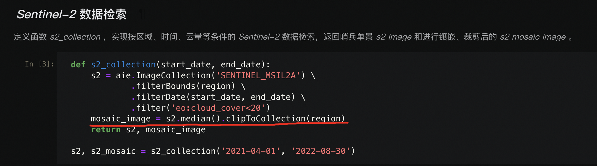
具体可以参考:https://engine-aiearth.aliyun.com/#/portal/case/10302 此回答整理自钉群“AI Earth地球科学云平台交流群”2024-03-06 20:07:53赞同 展开评论 打赏

版权声明:本文内容由阿里云实名注册用户自发贡献,版权归原作者所有,阿里云开发者社区不拥有其著作权,亦不承担相应法律责任。具体规则请查看《阿里云开发者社区用户服务协议》和《阿里云开发者社区知识产权保护指引》。如果您发现本社区中有涉嫌抄袭的内容,填写侵权投诉表单进行举报,一经查实,本社区将立刻删除涉嫌侵权内容。