ArcGIS Server开发系列的文章至今已经一年多了,虽然文章只有短短六篇,也比较基础,但值得高兴的是帮助了不少第一次接触ArcGIS Server的开发者,现在不少都已经完成一两个项目了,相信收获不小,有时间可以和大家一起分享经验。今天开始,我们将继续这个系列教程,争取覆盖ADF开发常用功能,以帮助更多的人轻松入门ADF开发。
目标:
实现简易的物流配送(VRP)
准备工作:
1.重新复习《ArcGIS Server 开发系列(六)--自定义 Tasks》
2.准备数据"%ArcGISInstallDir%\DeveloperKit\SamplesNET\Server\data\SanFranciscoNetwork"
3.发布NATasks.mxd地图服务,添加Network Analyst功能服务
4.MapResourceManager中添加一个ArcGIS Server Local类型服务
在这个应用中,多车配送的功能封装为一个自定义的Task,然后生成一个dll添加到ASP.Net工具箱中,由Web Mapping Application的Task Manager调用,更改自定义Task的Task Results Container为模板应用中的TaskResults1控件。
Web Mapping Application大家已经非常熟悉,现在的重点就在如何利用ArcGIS Server实现VRP功能。VRP全称vehicle routing problem,属于NP难问题,基本没有统一的方法来解决所有的VRP问题,只能根据具体的情况采用最合适的算法,咱们下面就利用ArcGIS Server模拟一个简单的应用场景,实现多车物流的配送计算。
自定义Task,需要构建Task的UI和业务逻辑,UI构建通过重写方法CreateChildControls完成,咱们最终实现的效果:
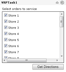
相应的代码比较容易看懂,结合上面实现的UI效果图和代码注释就能明白每部分代码所完成的功能,实现代码:

 protected
override
void
CreateChildControls()
protected
override
void
CreateChildControls() {
{ Controls.Clear(); base.CreateChildControls();
 Create top level table Orders Label Create and populate orders Listbox OrdersPanel Get Directions Button OnClick Event for executing task // Access the graphics layer so it is created and shown in the TOC ElementGraphicsLayer pointsGraphicsLayer = PointsGraphicsLayer;
 }
}
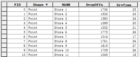
CreateChildControls用于构建VRPTask UI,除了界面要素之外,还需要从源数据中读取商店信息,如读取商店名称显示在界面上,当VRPTask中的商店被勾选上时,车辆将为该商店送货。商店供货信息存储在数据源中单独的一个图层中stores.shp,包含商店所需的货物数量和预计提供服务的时间。
VRPTask UI完成之后,接下来要设计VRP的业务逻辑,ArcGIS 9.3 Network Extension提供了一个基本的VRP解决方案,因此我们在发布NATasks服务的时候需要勾选Network Analyst功能,通过ServerContext去远程调用AO方法。
第一步,获取VRP分析图层。
IServerContext serverContext
=
MapResourceLocal.ServerContextInfo.ServerContext;IMap vrpMap
=
Utility.GetCartoIMap(MapInstance,
"
NA_MapResourceItem
"
);IGPMessages gpMessages
=
serverContext.CreateObject(
"
esriGeodatabase.GPMessages
"
)
as
IGPMessages;INALayer2 vrpNALayer
=
Utility.GetNALayer(
"
Vehicle Routing Problem
"
, vrpMap);INAContext vrpNAContext
=
vrpNALayer.CopyContext();INAContextEdit vrpNAContextEdit
=
vrpNAContext
as
INAContextEdit;vrpNAContextEdit.Bind(vrpNALayer.Context.NetworkDataset, gpMessages);
第二步,获取配送中心信息、商店信息、车辆信息和司机午餐时间。
IFeatureLayer depotsInputFLayer
=
Utility.GetFeatureLayer(
"
DistributionCenters
"
, vrpMap);IFeatureClass depotsInputFClass
=
depotsInputFLayer.FeatureClass;IFeatureCursor depotsInputFCursor
=
depotsInputFClass.Search(
null
,
false
);LoadAnalysisClass(serverContext, vrpNAContext,
"
Depots
"
, depotsInputFCursor
as
ICursor);
//
Load Orders
IFeatureLayer ordersInputFLayer
=
Utility.GetFeatureLayer(
"
Stores
"
, vrpMap);IFeatureClass ordersInputFClass
=
ordersInputFLayer.FeatureClass;IFeatureCursor ordersInputFCursor
=
ordersInputFClass.GetFeatures(oids,
true
);LoadAnalysisClass(serverContext, vrpNAContext,
"
Orders
"
, ordersInputFCursor
as
ICursor);
//
Load the Routes
ITable routesInputTable
=
Utility.GetStandaloneTable(
"
Vehicles
"
, vrpMap).Table;ICursor routesInputCursor
=
routesInputTable.Search(
null
,
true
);LoadAnalysisClass(serverContext, vrpNAContext,
"
Routes
"
, routesInputCursor
as
ICursor);
//
Load the Breaks
ITable breaksInputTable
=
Utility.GetStandaloneTable(
"
LunchBreaks
"
, vrpMap).Table;ICursor breaksInputCursor
=
breaksInputTable.Search(
null
,
true
);LoadAnalysisClass(serverContext, vrpNAContext,
"
Breaks
"
, breaksInputCursor
as
ICursor);
//
Message all of the network analysis agents that the analysis context has changed
vrpNAContextEdit.ContextChanged();
配送中心、商店信息均存储在物理图层中,分别对应DistributionCenters.shp、Stores.shp,车辆信息和司机午餐时间存储于Table表中。车辆Table包含物流配送过程中和车辆相关的一切信息,如起止配送中心、承载量、最多订单数、发车时间、最长驾驶时间、最长行驶距离等,司机午餐Table包含允许的午餐持续时间、允许的午餐时间范围等,这些都将用于ArcGIS VRP模型的计算中。
第三步,路径计算,做过ArcEngine Network Analyst开发的工程师对INASolver、INAVRPSolver一定非常熟悉了,调用过程比较简单,路径计算的同时处理系统反馈的消息信息。
gpMessages.Clear();INASolver naSolver
=
vrpNAContext.Solver;INAVRPSolver vrpSolver
=
naSolver
as
INAVRPSolver;vrpSolver.GenerateInternalRouteContext
=
true
;
//
Required for true-shape and directions
vrpSolver.DefaultDate
=
DateTime.Today;
//
Set the default date to be today
bool
partialResults
=
naSolver.Solve(vrpNAContext, gpMessages,
null
);
//
report errors
if
(partialResults
||
gpMessages.Count
>
0
)
{ StringBuilder sErrors = new StringBuilder(); for (int i = 0; i < gpMessages.Count; i++) sErrors.AppendLine(gpMessages.GetMessage(i).Description); Results = sErrors.ToString(); return;}
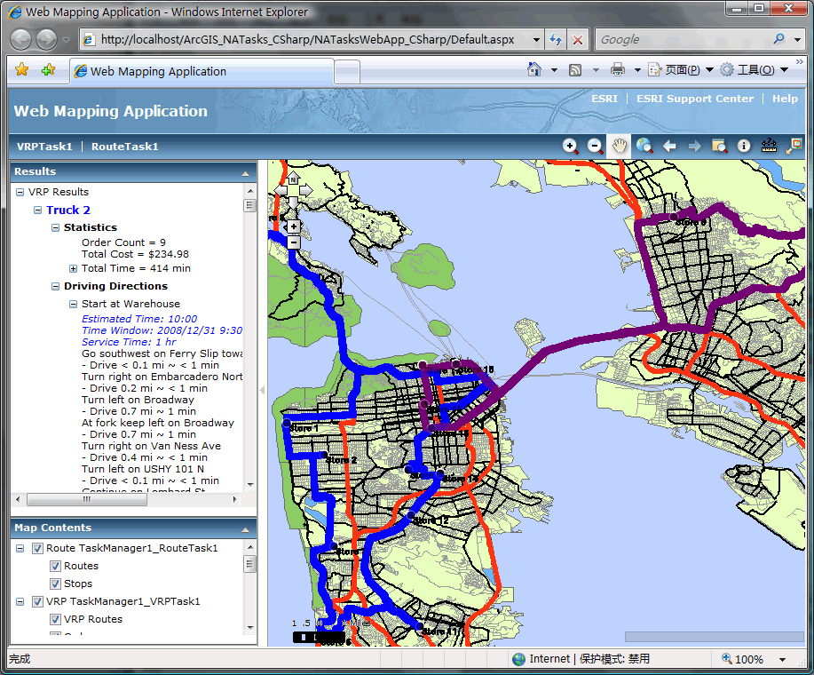
第四步,处理结果,VRP计算后最重要的结果就是生成的车辆分配情况、配送顺序和车辆配送路径,将车辆行驶的详细信息以图文并茂的方式展示出来。
//
Get Map's Spatial Reference (to project output geometries
ESRI.ArcGIS.ADF.Web.DataSources.ArcGISServer.MapFunctionality mf
=
(ESRI.ArcGIS.ADF.Web.DataSources.ArcGISServer.MapFunctionality)MapInstance.GetFunctionality(
"
NA_MapResourceItem
"
);SpatialReference mapSpatialReference
=
mf.MapDescription.SpatialReference;
//
Output result Routes and Stops
Utility.OutputRoutesAsGraphics(serverContext, vrpNAContext, RoutesGraphicsLayer, mapSpatialReference);Utility.OutputOrdersAsGraphics(serverContext, vrpNAContext, PointsGraphicsLayer, mapSpatialReference);
//
Create results node
TaskResultNode parentTaskResultNode
=
Utility.CreateTaskResultNode(
"
VRP Results
"
);parentTaskResultNode.Expanded
=
true
;
//
Get the Route Context from the results to use for directions
INAVRPResult vrpResult
=
vrpNAContext.Result
as
INAVRPResult;INAContext routeNAContext
=
vrpResult.InternalRouteContext;
//
Loop through the resulting routes and add items for each route (vehicle)
ISet routeSet
=
serverContext.CreateObject(
"
esriSystem.Set
"
)
as
ISet;IFeatureClass routeRoutesFClass
=
routeNAContext.NAClasses.get_ItemByName(
"
Routes
"
)
as
IFeatureClass;
int
routeNameIndex
=
routeRoutesFClass.FindField(
"
Name
"
);IFeatureCursor routesRouteFCursor
=
routeRoutesFClass.Search(
null
,
false
);
int
routeNumber
=
0
;IFeature routeFeature
=
routesRouteFCursor.NextFeature();
while
(routeFeature
!=
null
)
{ string routeName = routeFeature.get_Value(routeNameIndex).ToString(); Choose color for each route routeTaskResultNode.Expanded = true; parentTaskResultNode.Nodes.Add(routeTaskResultNode); // Add Statistics TaskResultNode vrpRouteStatisticsNode = Utility.GetVRPRouteStatisticsNode(serverContext, vrpNAContext, routeName); vrpRouteStatisticsNode.TextCellStyleAttributes.Add("font-weight", "bold"); routeTaskResultNode.Nodes.Add(vrpRouteStatisticsNode); // Add Directions // Get the directions for the specified route routeSet.RemoveAll(); routeSet.Add(routeFeature);// Get Directions // Generate the directions TaskResultNode directionsTaskResultNode = Utility.GetDirectionsNode(false, routeNAContext, routeSet); directionsTaskResultNode.TextCellStyleAttributes.Add("font-weight", "bold"); // Add the directions to the results node routeTaskResultNode.Nodes.Add(directionsTaskResultNode); routeNumber++; routeFeature = routesRouteFCursor.NextFeature();}
通过上述过程,完成了VRPTask的UI设计和业务逻辑程序,之后需要将应用重新生成为dll,添加到ASP.Net工具箱中,方便WebGIS应用调用该Task控件,我们在Web Mapping Application模板应用程序基础上添加VRPTask,运行后效果:
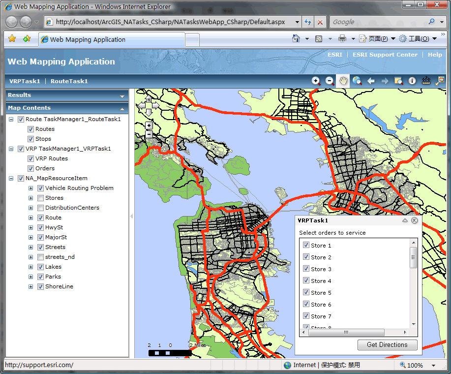 数据源vehicles table中包含三辆汽车的记录,在应用中勾选需要进行配送的商店,
例如选择15家商店,点击"Get Directions"执行VRP计算,生成结果如下所示:
我们可以发现,很多路径配送需要考虑的问题ArcGIS VRP模型都提供了一套非常简便的解决方案,能够解决一般情况下的VRP问题,但是就如文章前面所说,VRP没有统一的解决方法,但是至少我们可以选择基于ArcGIS Server进行扩展,请思考:
1.地图数据结构。
2.配送分区怎么考虑。
3.配送效率测试。
4.结对订单。
本文转自Flyingis博客园博客,原文链接:http://www.cnblogs.com/flyingis/archive/2008/12/31/1366170.html,如需转载请自行联系原作者