Landsat 1 MSS Collection 1 Tier 1 DN values, representing scaled, calibrated at-sensor radiance.
Landsat scenes with the highest available data quality are placed into Tier 1 and are considered suitable for time-series processing analysis. Tier 1 includes Level-1 Precision Terrain (L1TP) processed data that have well-characterized radiometry and are inter-calibrated across the different Landsat sensors. The georegistration of Tier 1 scenes will be consistent and within prescribed tolerances [<=12 m root mean square error (RMSE)]. All Tier 1 Landsat data can be considered consistent and inter-calibrated (regardless of sensor) across the full collection. See more information in the USGS docs.
For more information, see
Landsat 1 MSS Collection 1 Tier 1 DN值,代表经过缩放、校准的传感器辐射度。
具有最高可用数据质量的陆地卫星场景被归入第1级,并被认为适合进行时间序列处理分析。第一级包括一级精确地形(L1TP)处理的数据,这些数据具有良好的辐射测量特性,并在不同的Landsat传感器之间进行了相互校准。第1级场景的地理注册将是一致的,并在规定的公差范围内[<=12米均方根误差(RMSE)]。所有第1级Landsat数据都可以被认为是一致的,并且在整个集合中进行了相互校准(不管是哪个传感器)。参见USGS文档中的更多信息。
更多信息,见Landsat MSS产品信息页
Landsat 1 MSS Collection 1 Tier 2 DN values, representing scaled, calibrated at-sensor radiance.
Scenes not meeting Tier 1 criteria during processing are assigned to Tier 2. This includes Systematic terrain (L1GT) and Systematic (L1GS) processed scenes, as well as any L1TP scenes that do not meet the Tier 1 specifications due to significant cloud cover, insufficient ground control, and other factors. Users interested in Tier 2 scenes can analyze the RMSE and other properties to determine the suitability for use in individual applications and studies. See more information in the USGS docs.
For more information, see Landsat MSS Product Information Page
Landsat 1 MSS Collection 1 Tier 2 DN值,代表经过缩放、校准的传感器辐射度。
在处理过程中不符合第1级标准的场景被分配到第2级。这包括系统地形(L1GT)和系统(L1GS)处理过的场景,以及任何L1TP场景,这些场景由于严重的云层覆盖、地面控制不足和其他因素而不符合第1级规范。对第2级场景感兴趣的用户可以分析RMSE和其他属性,以确定是否适合用于个人应用和研究。更多信息见美国地质调查局的文件。
更多信息,见Landsat MSS产品信息页
Dataset Availability
1972-07-23T00:00:00 - 1978-01-07T00:00:00
Dataset Provider
Collection Snippet
ee.ImageCollection("LANDSAT/LM01/C01/T1")
Bands Table
| Name | Description | Resolution | Wavelength |
| B4 | Green | 60 meters | 0.5 - 0.6 µm |
| B5 | Red | 60 meters | 0.6 - 0.7 µm |
| B6 | Near Infrared 1 | 60 meters | 0.7 - 0.8 µm |
| B7 | Near Infrared 2 | 30 meters | 0.8 - 1.1 µm |
| BQA | Landsat Collection 1 QA Bitmask ([See Landsat QA page](https://www.usgs.gov/land-resources/nli/landsat/landsat-collection-1-level-1-quality-assessment-band)) | 60 meters | |
| BQA Bitmask |
|
||
| Name | Type | Description |
| CLOUD_COVER | Double | Percentage cloud cover (0-100), -1 = not calculated. |
| CLOUD_COVER_LAND | Double | Percentage cloud cover over land (0-100), -1 = not calculated. |
| COLLECTION_CATEGORY | String | Tier of scene. (T1 or T2) |
| COLLECTION_NUMBER | Double | Number of collection. |
| CORRECTION_GAIN_BAND_4 | String | Internal calibration gain method for band 4. |
| CORRECTION_GAIN_BAND_5 | String | Internal calibration gain method for band 5. |
| CORRECTION_GAIN_BAND_6 | String | Internal calibration gain method for band 6. |
| CORRECTION_GAIN_BAND_7 | String | Internal calibration gain method for band 7. |
| CPF_NAME | String | Calibration parameter file name. |
| DATA_CATEGORY | String | Current data category assigned to the data. Possible values: ("NOMINAL", "VALIDATION", "EXCHANGE", "TEST", "ENGINEERING") |
| DATA_TYPE | String | Data type identifier. (L1T or L1G) |
| DATA_TYPE_L0RP | String | Data type identifier string used to create the L0RP product. |
| DATE_ACQUIRED | String | Image acquisition date. "YYYY-MM-DD" |
| DATUM | String | Datum used in image creation. |
| EARTH_SUN_DISTANCE | Double | Earth sun distance in astronomical units (AU). |
| ELEVATION_SOURCE | String | Elevation model source used for standard terrain corrected (L1T) products. |
| ELLIPSOID | String | Ellipsoid used in image creation. |
| EPHEMERIS_TYPE | String | Ephemeris data type used to perform geometric correction. (Definitive or Predictive) |
| FILE_DATE | Double | File date in milliseconds since epoch. |
| GAIN_BAND_4 | String | Gain state for Band 1. (L = Low gain, H = High) |
| GAIN_BAND_5 | String | Gain state for Band 2. (L = Low gain, H = High) |
| GAIN_BAND_6 | String | Gain state for Band 3. (L = Low gain, H = High) |
| GAIN_BAND_7 | String | Gain state for Band 4. (L = Low gain, H = High) |
| GEOMETRIC_RMSE_MODEL | Double | Combined Root Mean Square Error (RMSE) of the geometric residuals (metres) in both across-track and along-track directions measured on the GCPs used in geometric precision correction. Not present in L1G products. |
| GEOMETRIC_RMSE_MODEL_X | Double | RMSE of the X direction geometric residuals (in metres) measured on the GCPs used in geometric precision correction. Not present in L1G products. |
| GEOMETRIC_RMSE_MODEL_Y | Double | RMSE of the Y direction geometric residuals (in metres) measured on the GCPs used in geometric precision correction. Not present in L1G products. |
| GEOMETRIC_RMSE_VERIFY | Double | RMSE of the geometric residuals (pixels) in both line and sample directions measured on the terrain-corrected product independently using GLS2000. |
| GEOMETRIC_RMSE_VERIFY_QUAD_LL | Double | RMSE of the geometric residuals (pixels) of the lower-left quadrant measured on the terrain-corrected product independently using GLS2000. |
| GEOMETRIC_RMSE_VERIFY_QUAD_LR | Double | RMSE of the geometric residuals (pixels) of the lower-right quadrant measured on the terrain-corrected product independently using GLS2000. |
| GEOMETRIC_RMSE_VERIFY_QUAD_UL | Double | RMSE of the geometric residuals (pixels) of the upper-left quadrant measured on the terrain-corrected product independently using GLS2000. |
| GEOMETRIC_RMSE_VERIFY_QUAD_UR | Double | RMSE of the geometric residuals (pixels) of the upper-right quadrant measured on the terrain-corrected product independently using GLS2000. |
| GRID_CELL_SIZE_REFLECTIVE | Double | Grid cell size used in creating the image for the reflective band. |
| GROUND_CONTROL_POINTS_MODEL | Double | The number of ground control points used. Not used in L1GT products. Values: 0 - 999 (0 is used for L1T products that have used Multi-scene refinement). |
| GROUND_CONTROL_POINTS_VERIFY | Double | The number of ground control points used in the verification of the terrain corrected product. Values: -1 to 1615 (-1 = not available) |
| GROUND_CONTROL_POINTS_VERSION | Double | The number of ground control points used in the verification of the terrain corrected product. Values: -1 to 1615 (-1 = not available) |
| IMAGE_QUALITY | Double | Image quality, 0 = worst, 9 = best, -1 = quality not calculated |
| LANDSAT_PRODUCT_ID | String | The naming convention of each Landsat Collection 1 Level-1 image based on acquisition parameters and processing parameters. Format: LXSS_LLLL_PPPRRR_YYYYMMDD_yyyymmdd_CC_TX * L = Landsat * X = Sensor (O = Operational Land Imager, T = Thermal Infrared Sensor, C = Combined OLI/TIRS) * SS = Satellite (08 = Landsat 8) * LLLL = Processing Correction Level (L1TP = precision and terrain, L1GT = systematic terrain, L1GS = systematic) * PPP = WRS Path * RRR = WRS Row * YYYYMMDD = Acquisition Date expressed in Year, Month, Day * yyyymmdd = Processing Date expressed in Year, Month, Day * CC = Collection Number (01) * TX = Collection Category (RT = Real Time, T1 = Tier 1, T2 = Tier 2) |
| LANDSAT_SCENE_ID | String | The Pre-Collection naming convention of each image is based on acquisition parameters. This was the naming convention used prior to Collection 1. Format: LXSPPPRRRYYYYDDDGSIVV * L = Landsat * X = Sensor (O = Operational Land Imager, T = Thermal Infrared Sensor, C = Combined OLI/TIRS) * S = Satellite (08 = Landsat 8) * PPP = WRS Path * RRR = WRS Row * YYYY = Year of Acquisition * DDD = Julian Day of Acquisition * GSI = Ground Station Identifier * VV = Version |
| MAP_PROJECTION | String | Projection used to represent the 3-dimensional surface of the earth for the Level-1 product. |
| MAP_PROJECTION_L0RA | String | L0RA map projection selectively applied to HDTs based on geographic location. Used for processed archive data. |
| ORIENTATION | String | Orientation used in creating the image. Values: NOMINAL = Nominal Path, NORTH_UP = North Up, TRUE_NORTH = True North, USER = User |
| PRESENT_BAND_4 | String | Presence of Band 4 (Y = Yes, N = No, M = Missing, I = Unknown) |
| PRESENT_BAND_5 | String | Presence of Band 5 (Y = Yes, N = No, M = Missing, I = Unknown) |
| PRESENT_BAND_6 | String | Presence of Band 6 (Y = Yes, N = No, M = Missing, I = Unknown) |
| PRESENT_BAND_7 | String | Presence of Band 7 (Y = Yes, N = No, M = Missing, I = Unknown) |
| PROCESSING_SOFTWARE_VERSION | String | Name and version of the processing software used to generate the L1 product. |
| RADIANCE_ADD_BAND_4 | Double | Additive rescaling factor used to convert calibrated DN to radiance for Band 4. |
| RADIANCE_ADD_BAND_5 | Double | Additive rescaling factor used to convert calibrated DN to radiance for Band 5. |
| RADIANCE_ADD_BAND_6 | Double | Additive rescaling factor used to convert calibrated DN to radiance for Band 6. |
| RADIANCE_ADD_BAND_7 | Double | Additive rescaling factor used to convert calibrated DN to radiance for Band 7. |
| RADIANCE_MULT_BAND_4 | Double | Multiplicative rescaling factor used to convert calibrated Band 4 DN to radiance. |
| RADIANCE_MULT_BAND_5 | Double | Multiplicative rescaling factor used to convert calibrated Band 5 DN to radiance. |
| RADIANCE_MULT_BAND_6 | Double | Multiplicative rescaling factor used to convert calibrated Band 6 DN to radiance. |
| RADIANCE_MULT_BAND_7 | Double | Multiplicative rescaling factor used to convert calibrated Band 7 DN to radiance. |
| REFLECTANCE_ADD_BAND_4 | Double | Additive rescaling factor used to convert calibrated Band 4 DN to reflectance. |
| REFLECTANCE_ADD_BAND_5 | Double | Additive rescaling factor used to convert calibrated Band 5 DN to reflectance. |
| REFLECTANCE_ADD_BAND_6 | Double | Additive rescaling factor used to convert calibrated Band 6 DN to reflectance. |
| REFLECTANCE_ADD_BAND_7 | Double | Additive rescaling factor used to convert calibrated Band 7 DN to reflectance. |
| REFLECTANCE_MULT_BAND_4 | Double | Multiplicative factor used to convert calibrated Band 4 DN to reflectance. |
| REFLECTANCE_MULT_BAND_5 | Double | Multiplicative factor used to convert calibrated Band 5 DN to reflectance. |
| REFLECTANCE_MULT_BAND_6 | Double | Multiplicative factor used to convert calibrated Band 6 DN to reflectance. |
| REFLECTANCE_MULT_BAND_7 | Double | Multiplicative factor used to convert calibrated Band 7 DN to reflectance. |
| REFLECTIVE_LINES | Double | Number of product lines for the reflective bands. |
| REFLECTIVE_SAMPLES | Double | Number of product samples for the reflective bands. |
| REQUEST_ID | String | Request id, nnnyymmdd0000_0000 * nnn = node number * yy = year * mm = month * dd = day |
| RESAMPLING_OPTION | String | Resampling option used in creating the image. |
| SATURATION_BAND_4 | String | Flag indicating saturated pixels for band 4 ('Y'/'N') |
| SATURATION_BAND_5 | String | Flag indicating saturated pixels for band 5 ('Y'/'N') |
| SATURATION_BAND_6 | String | Flag indicating saturated pixels for band 6 ('Y'/'N') |
| SATURATION_BAND_7 | String | Flag indicating saturated pixels for band 7 ('Y'/'N') |
| SCENE_CENTER_TIME | String | Scene center time of acquired image. HH:MM:SS.SSSSSSSZ * HH = Hour (00-23) * MM = Minutes * SS.SSSSSSS = Fractional seconds * Z = "Zulu" time (same as GMT) |
| SENSOR_ID | String | Sensor used to capture data. |
| SPACECRAFT_ID | String | Spacecraft identification. |
| STATION_ID | String | Ground Station/Organisation that received the data. |
| SUN_AZIMUTH | Double | Sun azimuth angle in degrees for the image center location at the image centre acquisition time. |
| SUN_ELEVATION | Double | Sun elevation angle in degrees for the image center location at the image centre acquisition time. |
| UTM_ZONE | Double | UTM zone number used in product map projection. |
| WRS_PATH | Double | The WRS orbital path number (001 - 251). |
| WRS_ROW | Double | Landsat satellite WRS row (001-248). |
使用说明:
Landsat datasets are federally created data and therefore reside in the public domain and may be used, transferred, or reproduced without copyright restriction.
Acknowledgement or credit of the USGS as data source should be provided by including a line of text citation such as the example shown below.
(Product, Image, Photograph, or Dataset Name) courtesy of the U.S. Geological Survey
Example: Landsat-7 image courtesy of the U.S. Geological Survey
See the USGS Visual Identity System Guidance for further details on proper citation and acknowledgement of USGS products.
Landsat数据集是联邦创建的数据,因此属于公共领域,可以在没有版权限制的情况下使用、转让或复制。
对美国地质调查局作为数据来源的确认或信用,应通过包括一行文字引用来提供,如下面的例子。
(产品、图像、照片或数据集名称)由美国地质调查局提供。
例子。Landsat-7图像由美国地质调查局提供
请参阅美国地质调查局视觉识别系统指南,了解有关美国地质调查局产品的正确引用和鸣谢的进一步细节。
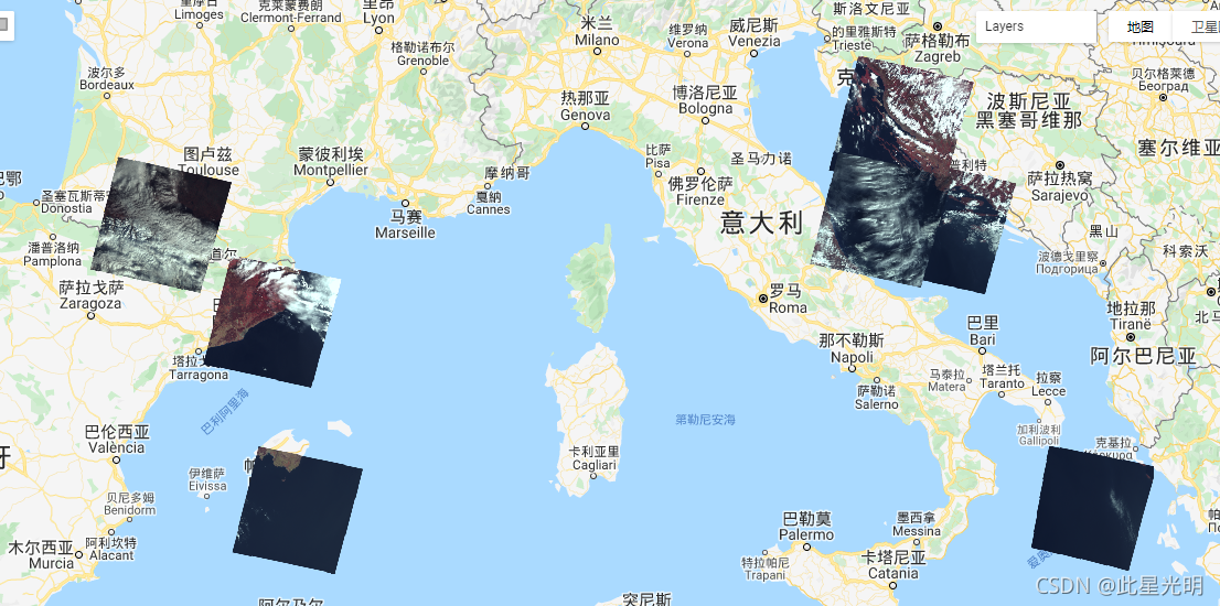
代码:
var dataset = ee.ImageCollection('LANDSAT/LM01/C01/T1')
                  .filterDate('1974-01-01', '1978-12-31');
var nearInfrared321 = dataset.select(['B6', 'B5', 'B4']);
var nearInfrared321Vis = {};
Map.setCenter(6.746, 46.529, 6);
Map.addLayer(nearInfrared321, nearInfrared321Vis, 'Near Infrared (321)');
代码:
var dataset = ee.ImageCollection('LANDSAT/LM01/C01/T2')
                  .filterDate('1974-01-01', '1978-12-31');
var nearInfrared321 = dataset.select(['B6', 'B5', 'B4']);
var nearInfrared321Vis = {};
Map.setCenter(6.746, 46.529, 6);
Map.addLayer(nearInfrared321, nearInfrared321Vis, 'Near Infrared (321)');
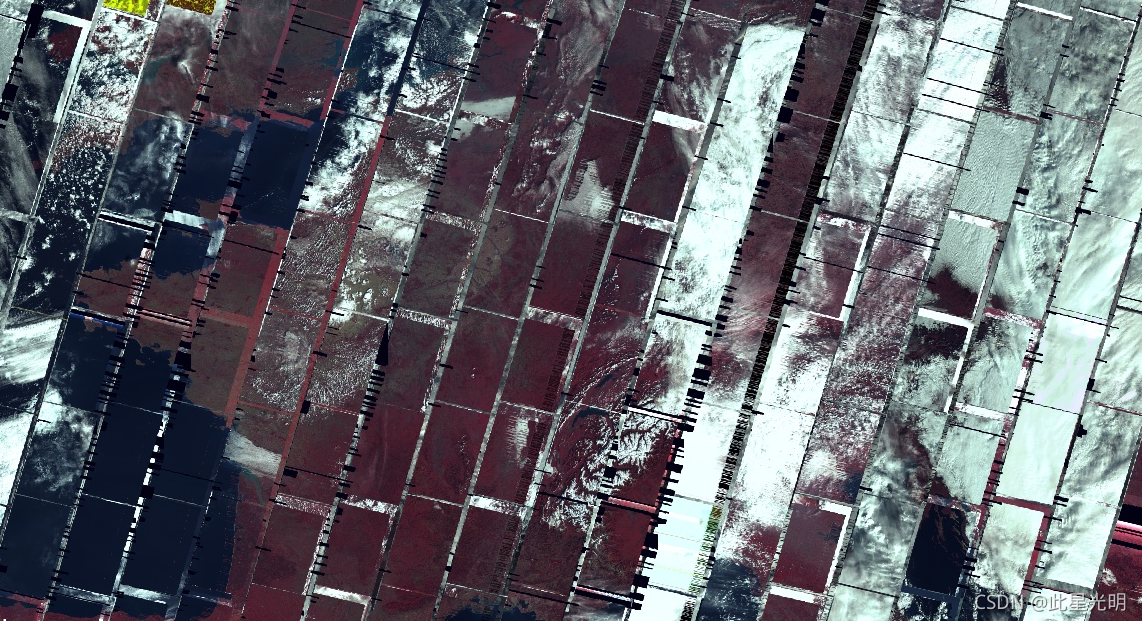
注:有很多影像是缺失的,所以我们只能看运气,拼接的条带和色差非常明显,所以之前的数据很少有人用到。