The Global Forecast System (GFS) is a weather forecast model produced by the National Centers for Environmental Prediction (NCEP). The GFS dataset consists of selected model outputs (described below) as gridded forecast variables. The 384-hour forecasts, with 3-hour forecast interval, are made at 6-hour temporal resolution (i.e. updated four times daily). Use the 'creation_time' and 'forecast_time' properties to select data of interest.
The GFS is a coupled model, composed of an atmosphere model, an ocean model, a land/soil model, and a sea ice model which work together to provide an accurate picture of weather conditions. See history of recent modifications to the global forecast/analysis system, the model performance statistical web page, and the documentation homepage for more information.
全球预测系统(GFS)是由美国国家环境预测中心(NCEP)制作的一个天气预报模型。GFS数据集由选定的模型输出(如下所述)组成,作为网格化的预测变量。384小时的预测,预测间隔为3小时,以6小时的时间分辨率进行(即每天更新4次)。使用 "创建时间 "和 "预报时间 "属性来选择感兴趣的数据。
GFS是一个耦合模型,由一个大气模型、一个海洋模型、一个土地/土壤模型和一个海冰模型组成,它们一起工作以提供一个准确的天气状况图。更多信息见全球预报/分析系统最近的修改历史、模型性能统计网页和文件主页。
Dataset Availability
2015-07-01T00:00:00 - 2021-09-30T00:00:00
Dataset Provider
Collection Snippet
ee.ImageCollection("NOAA/GFS0P25")
Resolution
27830 meters
Bands Table
| Name | Description | Min* | Max* | Units |
| temperature_2m_above_ground | Temperature 2m above ground | -69.18 | 52.25 | °C |
| specific_humidity_2m_above_ground | Specific humidity 2m above ground | 0 | 0.03 | kg/kg |
| relative_humidity_2m_above_ground | Relative humidity 2m above ground | 1 | 100.05 | % |
| u_component_of_wind_10m_above_ground | U component of wind 10m above ground | -60.73 | 59.28 | m/s |
| v_component_of_wind_10m_above_ground | V component of wind 10m above ground | -63.78 | 59.39 | m/s |
| total_precipitation_surface | Until 2019-11-07 06:00:00, this field represents the precipitation at surface at the forecasted time. After that date, this field holds the cumulative precipitation at surface added together from all forecasts starting from hour 0 (only for assets with forecast_hours > 0) | 0 | 626.75 | kg/m^2 |
| precipitable_water_entire_atmosphere | Precipitable water for entire atmosphere | 0 | 100 | kg/m^2 |
| total_cloud_cover_entire_atmosphere | Total cloud cover for entire atmosphere (only for assets with forecast_hours > 0) | 0 | 100 | % |
| downward_shortwave_radiation_flux | Downward shortwave radiation flux (only for assets with forecast_hours > 0) | 0 | 1230 | W/m^2 |
* = Values are estimated
影像属性:
| Name | Type | Description |
| creation_time | Double | Time of creation |
| forecast_hours | Double | Forecast hours |
| forecast_time | Double | Forecast time |
数据使用:
NOAA data, information, and products, regardless of the method of delivery, are not subject to copyright and carry no restrictions on their subsequent use by the public. Once obtained, they may be put to any lawful use. The forgoing data is in the public domain and is being provided without restriction on use and distribution.
数据引用:
Alpert, J., 2006 Sub-Grid Scale Mountain Blocking at NCEP, 20th Conf. WAF/16 Conf. NWP P2.4.
Alpert, J. C., S-Y. Hong and Y-J. Kim: 1996, Sensitivity of cyclogenesis to lower troposphere enhancement of gravity wave drag using the EMC MRF”, Proc. 11 Conf. On NWP, Norfolk, 322-323.
Alpert,J,, M. Kanamitsu, P. M. Caplan, J. G. Sela, G. H. White, and E. Kalnay, 1988: Mountain induced gravity wave drag parameterization in the NMC medium-range forecast model. Pre-prints, Eighth Conf. on Numerical Weather Prediction, Baltimore, MD, Amer. Meteor. Soc., 726-733.
Buehner, M., J. Morneau, and C. Charette, 2013: Four-dimensional ensemble-variational data assimilation for global deterministic weather prediction. Nonlinear Processes Geophys., 20, 669–682.
Chun, H.-Y., and J.-J. Baik, 1998: Momentum Flux by Thermally Induced Internal Gravity Waves and Its Approximation for Large-Scale Models. J. Atmos. Sci., 55, 3299–3310.
Chun, H.-Y., Song, I.-S., Baik, J.-J. and Y.-J. Kim. 2004: Impact of a Convectively Forced Gravity Wave Drag Parameterization in NCAR CCM3. J. Climate, 17, 3530–3547.
Chun, H.-Y., Song, M.-D., Kim, J.-W., and J.-J. Baik, 2001: Effects of Gravity Wave Drag Induced by Cumulus Convection on the Atmospheric General Circulation. J. Atmos. Sci., 58, 302–319.
Clough, S.A., M.W. Shephard, E.J. Mlawer, J.S. Delamere, M.J. Iacono, K.Cady-Pereira, S. Boukabara, and P.D. Brown, 2005: Atmospheric radiative transfer modeling: A summary of the AER codes, J. Quant. Spectrosc. Radiat. Transfer, 91, 233-244. doi:10.1016/j.jqsrt.2004.05.058
Ebert, E.E., and J.A. Curry, 1992: A parameterization of ice cloud optical properties for climate models. J. Geophys. Res., 97, 3831-3836.
Fu, Q., 1996: An Accurate Parameterization of the Solar Radiative Properties of Cirrus Clouds for Climate Models. J. Climate, 9, 2058-2082.
Han, J., and H.-L. Pan, 2006: Sensitivity of hurricane intensity forecast to convective momentum transport parameterization. Mon. Wea. Rev., 134, 664-674.
Han, J., and H.-L. Pan, 2011: Revision of convection and vertical diffusion schemes in the NCEP global forecast system. Weather and Forecasting, 26, 520-533.
Han, J., M. Witek, J. Teixeira, R. Sun, H.-L. Pan, J. K. Fletcher, and C. S. Bretherton, 2016: Implementation in the NCEP GFS of a hybrid eddy-diffusivity mass-flux (EDMF) boundary layer parameterization with dissipative heating and modified stable boundary layer mixing. Weather and Forecasting, 31, 341-352.
Hou, Y., S. Moorthi and K. Campana, 2002: Parameterization of Solar Radiation Transfer in the NCEP Models, NCEP Office Note #441, pp46. Available here
Hu, Y.X., and K. Stamnes, 1993: An accurate parameterization of the radiative properties of water clouds suitable for use in climate models. J. Climate, 6, 728-74.
Iacono, M.J., E.J. Mlawer, S.A. Clough, and J.-J. Morcrette, 2000: Impact of an improved longwave radiation model, RRTM, on the energy budget and thermodynamic properties of the NCAR community climate model, CCM3, J. Geophys. Res., 105(D11), 14,873–14,890.2.
Johansson, Ake, 2008: Convectively Forced Gravity Wave Drag in the NCEP Global Weather and Climate Forecast Systems, SAIC/Environmental Modelling Center internal report.
Juang, H-M, et al. 2014:Regional Spectral Model workshop in memory of John Roads and Masao Kanamitsu, BAMS, A. Met. Soc, ES61-ES65.
Kim, Y.-J., and A. Arakawa (1995), Improvement of orographic gravity wave parameterization using a mesoscale gravity-wave model, J. Atmos. Sci.,52, 875–1902.
Kleist, D. T., 2012: An evaluation of hybrid variational-ensemble data assimilation for the NCEP GFS , Ph.D. Thesis, Dept. of Atmospheric and Oceanic Science, University of Maryland-College Park, 149 pp.
Lott, F and M. J. Miller: 1997, “A new subgrid-scale orographic drag parameterization: Its formulation and testing”, QJRMS, 123, pp101-127.
Mlawer, E.J., S.J. Taubman, P.D. Brown, M.J. Iacono, and S.A. Clough, 1997: Radiative transfer for inhomogeneous atmospheres: RRTM, a validated correlated-k model for the longwave. J. Geophys. Res., 102, 16663-16682.
Sela, J., 2009: The implementation of the sigma-pressure hybrid coordinate into the GFS. NCEP Office Note #461, pp25.
Sela, J., 2010: The derivation of sigmapressure hybrid coordinate semi-Lagrangian model equations for the GFS. NCEP Office Note #462 pp31.
Yang, F., 2009: On the Negative Water Vapor in the NCEP GFS: Sources and Solution. 23rd Conference on Weather Analysis and Forecasting/19th Conference on Numerical Weather Prediction, 1-5 June 2009, Omaha, NE.
Yang, F., K. Mitchell, Y. Hou, Y. Dai, X. Zeng, Z. Wang, and X. Liang, 2008: Dependence of land surface albedo on solar zenith angle: observations and model parameterizations. Journal of Applied Meteorology and Climatology.No.11, Vol 47, 2963-2982.
代码:
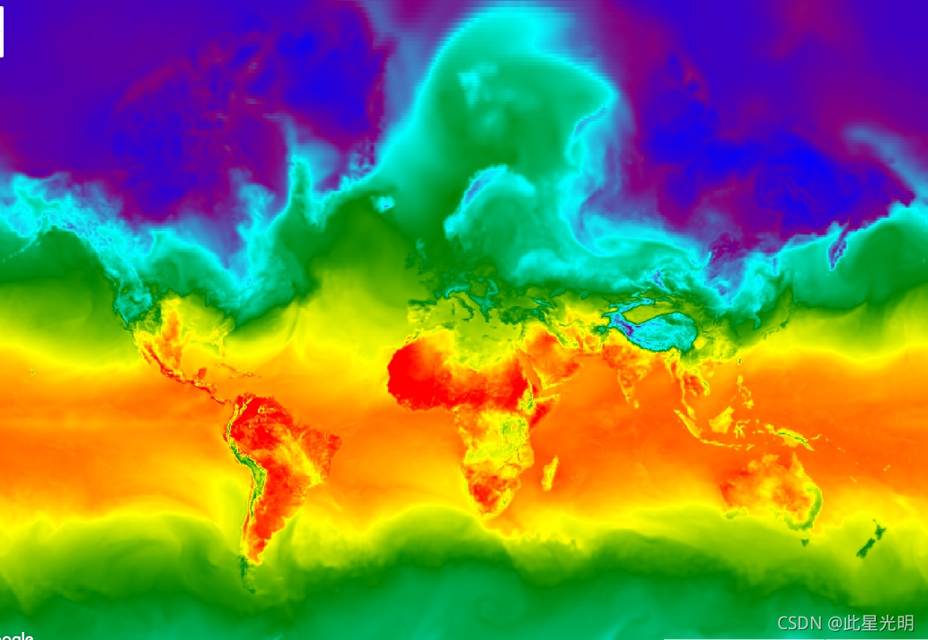
var dataset = ee.ImageCollection('NOAA/GFS0P25')
                  .filter(ee.Filter.date('2018-03-01', '2018-03-02'));
var temperatureAboveGround = dataset.select('temperature_2m_above_ground');
var visParams = {
  min: -40.0,
  max: 35.0,
  palette: ['blue', 'purple', 'cyan', 'green', 'yellow', 'red'],
};
Map.setCenter(71.72, 52.48, 3.0);
Map.addLayer(temperatureAboveGround, visParams, 'Temperature Above Ground');