The NOAA Climate Data Record (CDR) of AVHRR Normalized Difference Vegetation Index (NDVI) contains gridded daily NDVI derived from the NOAA AVHRR Surface Reflectance product. It provides a measurement of surface vegetation coverage activity, gridded at a resolution of 0.05° and computed globally over land surfaces.
Known issues with this dataset include:
- TIMEOFDAY variable contains values that are too large by 1 day
- Latitude values are not correctly associated with the center of the grid cell, error is < 0.002 degrees
- Longitude values are not correctly associated with the center of the grid cell, error is < 0.02 degrees
See technical note from the data provider.
NOAA气候数据记录(CDR)的AVHRR归一化植被指数(NDVI)包含从NOAA AVHRR表面反射产品中得到的网格化的每日NDVI。它提供了地表植被覆盖活动的测量,网格化的分辨率为0.05°,在全球范围内对陆地表面进行计算。
这个数据集的已知问题包括。
TIMEOFDAY变量包含的数值过大,超过1天。
纬度值与网格单元的中心没有正确关联,误差<0.002度
经度值与网格单元的中心没有正确关联,误差< 0.02度
见数据提供者的技术说明。
Dataset Availability
1981-06-24T00:00:00 - 2019-05-16T00:00:00
Dataset Provider
Collection Snippet
ee.ImageCollection("NOAA/CDR/AVHRR/NDVI/V4")
Resolution
5566 meters
Bands Table
| Name | Description | Min* | Max* | Units | Scale |
| NDVI | Normalized difference vegetation index | -9998 | 9998 | 0.0001 | |
| TIMEOFDAY | Hours since start of day | 0 | 2400 | hours | 0.01 |
| QA | Quality control bit flags | 0 | |||
| QA Bitmask |
|
||||
* = Values are estimated
影像属性:
| Name | Type | Description |
| status | String | 'provisional' or 'permanent' |
使用说明:
The NOAA CDR Program’s official distribution point for CDRs is NOAA’s National Climatic Data Center which provides sustained, open access and active data management of the CDR packages and related information in keeping with the United States’ open data policies and practices as described in the President's Memorandum on "Open Data Policy" and pursuant to the Executive Order of May 9, 2013, "Making Open and Machine Readable the New Default for Government Information". In line with these policies, the CDR data sets are nonproprietary, publicly available, and no restrictions are placed upon their use. For more information, see the Fair Use of NOAA's CDR Data Sets, Algorithms and Documentation pdf
引用:
Eric Vermote, Chris Justice, Ivan Csiszar, Jeff Eidenshink, Ranga Myneni, Frederic Baret, Ed Masuoka, Robert Wolfe, Martin Claverie and NOAA CDR Program (2014): NOAA Climate Data Record (CDR) of Normalized Difference Vegetation Index (NDVI), Version 4. [indicate subset used]. NOAA National Climatic Data Center. doi:10.7289/V5PZ56R6
代码:
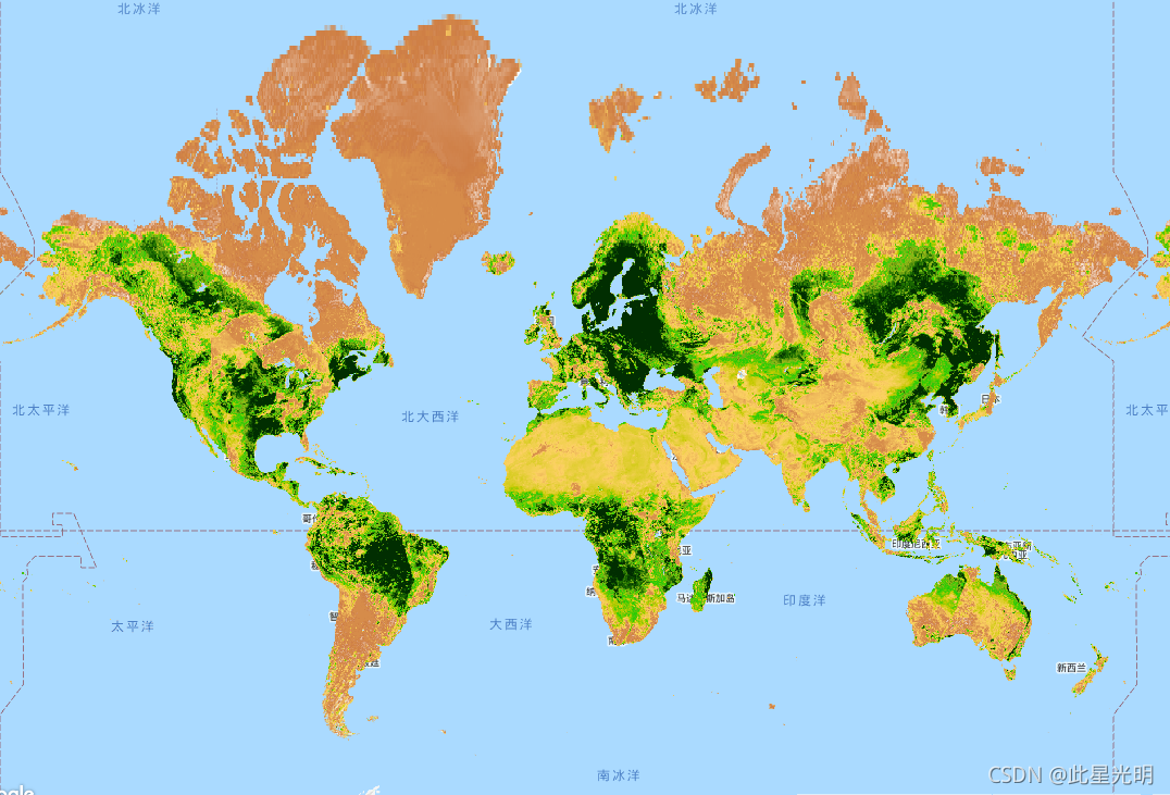
var dataset = ee.ImageCollection('NOAA/CDR/AVHRR/NDVI/V4')
                  .filter(ee.Filter.date('2018-05-01', '2018-06-01'));
var ndvi = dataset.select('NDVI');
var ndviVis = {
  min: -1000.0,
  max: 5000.0,
  palette: [
    'ffffff', 'ce7e45', 'fcd163', 'c6ca02', '22cc04', '99b718', '207401',
    '012e01'
  ],
};
Map.setCenter(7.71, 17.93, 2);
Map.addLayer(ndvi, ndviVis, 'NDVI');
代码:
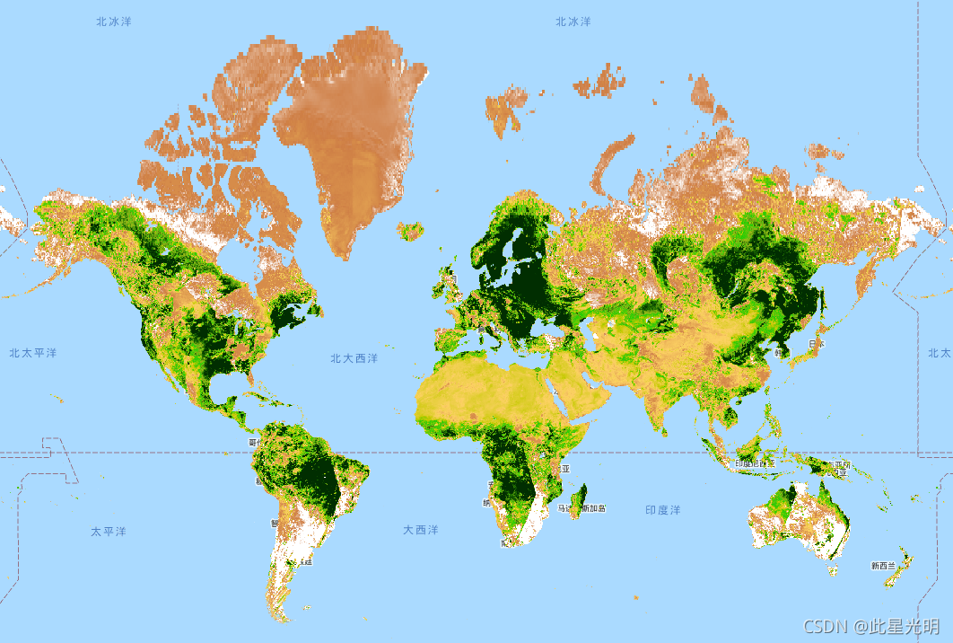
var dataset = ee.ImageCollection('NOAA/CDR/AVHRR/NDVI/V5')
                  .filter(ee.Filter.date('2018-05-01', '2018-06-01'));
var ndvi = dataset.select('NDVI');
var ndviVis = {
  min: -1000.0,
  max: 5000.0,
  palette: [
    'ffffff', 'ce7e45', 'fcd163', 'c6ca02', '22cc04', '99b718', '207401',
    '012e01'
  ],
};
Map.setCenter(7.71, 17.93, 2);
Map.addLayer(ndvi, ndviVis, 'NDVI');