本产品是陆地表面的温度。 更新版本的 JAXA/GCOM-C/L3/LAND/LST/V2也可用于此数据集,该数据集使用此算法进行处理。 GCOM-C 进行长期和持续的全球观测和数据收集,以阐明辐射收支和碳循环波动背后的机制,从而对未来温度上升做出准确预测。同时,与有气候数值模型的研究机构合作,有助于减少气候数值模型得出的温升预测误差,提高各种环境变化的预测精度。安装在 GCOM-C 上的 SGLI 是安装在 ADEOS-II (MIDORI II) 上的 Global Imager (GLI) 的连续传感器,是测量从近紫外到热红外区域 (380 nm-12 um) 的辐射的成像辐射计在 19 个频道中。在日本附近的中纬度地区,地面观测宽度超过 1,000 公里,可以进行大约每两天一次的全球观测。此外,SGLI 实现了比同类全局传感器更高的分辨率,并具有偏振观测功能和多角度观测功能。
Dataset Availability
2018-01-01T00:00:00 - 2020-06-28T00:00:00
Dataset Provider
Global Change Observation Mission (GCOM)
Collection Snippet
ee.ImageCollection("JAXA/GCOM-C/L3/LAND/LST/V2")
Resolution
2.5 arc minutes
Bands Table
| Name | Description | Min* | Max* | Units |
| LST_AVE | Temperature of land surface. | 0 | 65531 | K |
| LST_QA_flag | LST QA | |||
| LST_QA_flag Bitmask |
|
|||
* = Values are estimated
| Name | Type | Description |
| ALGORITHM_VERSION | String | Algorithm version |
| GRID_INTERVAL | String | Spatial resolution |
| GRID_INTERVAL_UNIT | String | Unit of GRID_INTERVAL |
| IMAGE_END_TIME | String | Image acquisition end time |
| IMAGE_START_TIME | String | Image acquisition start time |
| PROCESSING_RESULT | String | Good, Fair, Poor, NG |
| PROCESSING_UT | String | Processing time |
| PRODUCT_FILENAME | String | Source filename |
| PRODUCT_VERSION | String | Product version |
| SATELLITE_DIRECTION | String | Satellite orbit direction |
| LST_AVE_OFFSET | String | Offset |
| LST_AVE_SLOPE | String | Slope |
影像属性:
| ALGORITHM_VERSION | String | Algorithm version |
| GRID_INTERVAL | String | Spatial resolution |
| GRID_INTERVAL_UNIT | String | Unit of GRID_INTERVAL |
| IMAGE_END_TIME | String | Image acquisition end time |
| IMAGE_START_TIME | String | Image acquisition start time |
| PROCESSING_RESULT | String | Good, Fair, Poor, NG |
| PROCESSING_UT | String | Processing time |
| PRODUCT_FILENAME | String | Source filename |
| PRODUCT_VERSION | String | Product version |
| SATELLITE_DIRECTION | String | Satellite orbit direction |
| LST_AVE_OFFSET | String | Offset |
| LST_AVE_SLOPE | String | Slope |
数据说明:
This dataset is free to use without any restrictions (including commercial use). Anyone wishing to publish analyzed results or value added data products should properly credit the original G-Portal data, e.g., "PR data by Japan Aerospace Exploration Agency". For value added data products, please indicate the credit of the original G-Portal data, e.g., "Original data for this value added data product was provided by Japan Aerospace Exploration Agency."
See G-Portal's terms of service (Article 7) for additional information.
引用:
Moriyama, M. (Sep. 2014). GCOM–C1/SGLI Land Surface Temperature Product Algorithm Theoretical Basis Document (Version 1). Retrieved from https://suzaku.eorc.jaxa.jp/GCOM_C/data/ATBD/ver1/LST-ATBD_2014.pdf
代码:
代码:
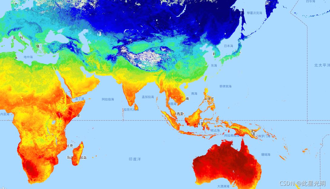
var dataset = ee.ImageCollection("JAXA/GCOM-C/L3/LAND/LST/V2")
                .filterDate('2020-01-01', '2020-02-01');
// Multiply with slope coefficient
var dataset = dataset.mean().multiply(0.02).log10();
var visualization = {
  bands: ['LST_AVE'],
  min: 2.4,
  max: 2.5,
  palette: [
    "040274","040281","0502a3","0502b8","0502ce","0502e6",
    "0602ff","235cb1","307ef3","269db1","30c8e2","32d3ef",
    "3be285","3ff38f","86e26f","3ae237","b5e22e","d6e21f",
    "fff705","ffd611","ffb613","ff8b13","ff6e08","ff500d",
    "ff0000","de0101","c21301","a71001","911003",
  ]
};
Map.setCenter(128.45, 33.33, 5);
Map.addLayer(dataset, visualization, "Land Surface Temperature");