Google Earth Engine ——数据全解析专辑(世界第 4 版网格化人口 (GPWv4) 修订版30 弧秒1公里格网)人口计数和密度网格的输入单元的平均面积数据集

简介: Google Earth Engine ——数据全解析专辑(世界第 4 版网格化人口 (GPWv4) 修订版30 弧秒1公里格网)人口计数和密度网格的输入单元的平均面积数据集

The Gridded Population of World Version 4 (GPWv4), Revision 11 models the distribution of global human population for the years 2000, 2005, 2010, 2015, and 2020 on 30 arc-second (approximately 1km) grid cells. Population is distributed to cells using proportional allocation of population from census and administrative units. Population input data are collected at the most detailed spatial resolution available from the results of the 2010 round of censuses, which occurred between 2005 and 2014. The input data are extrapolated to produce population estimates for each modeled year.


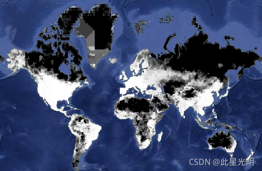
The mean area of the input unit(s) from which population count and density grids are created.


世界第 4 版网格化人口 (GPWv4) 修订版 11 对 2000、2005、2010、2015 和 2020 年在 30 弧秒(约 1 公里)网格单元上的全球人口分布进行建模。使用人口普查和行政单位的人口比例分配将人口分配到单元格。人口输入数据是在 2010 年普查结果中可用的最详细的空间分辨率收集的,普查结果发生在 2005 年和 2014 年之间。输入数据被外推以产生每个建模年份的人口估计值。


创建人口计数和密度网格的输入单元的平均面积。

Resolution

30 arc seconds

Bands Table

Name Description Min* Max*
mean_administrative_unit_area Displays a quantitative surface that indicates the size of the input units in square kilometers from which population count and density grids are derived. 0 767642


代码:

var dataset = ee.Image("CIESIN/GPWv411/GPW_Mean_Administrative_Unit_Area");
var raster = dataset.select('mean_administrative_unit_area');
var raster_vis = {
  "min": 0.0,
  "palette": [
    "ffffff",
    "747474",
    "656565",
    "3c3c3c",
    "2f2f2f",
    "000000"
  ],
  "max": 40000.0
};
Map.setCenter(-88.6, 26.4, 1);
Map.addLayer(raster, raster_vis, 'mean_administrative_unit_area');


相关文章
|
机器学习/深度学习 人工智能 算法
Google DeepMind新产物: 行星级卫星嵌入数据集(10m)光学+雷达+DEM+climate...
Google 推出 Earth Engine 卫星嵌入数据集,利用 AI 将一年的多源卫星数据压缩至每个 10 米像素,实现高效地理空间分析。基于 AlphaEarth Foundations 模型,该数据集提供 64 维嵌入向量,支持相似性搜索、变化检测、自动聚类和精准分类,助力环境研究与应用。
744 0
|
存储 数据库 Android开发
🔥Android Jetpack全解析!拥抱Google官方库,让你的开发之旅更加顺畅无阻!🚀
【7月更文挑战第28天】在Android开发中追求高效稳定的路径?Android Jetpack作为Google官方库集合,是你的理想选择。它包含多个独立又协同工作的库,覆盖UI到安全性等多个领域,旨在减少样板代码,提高开发效率与应用质量。Jetpack核心组件如LiveData、ViewModel、Room等简化了数据绑定、状态保存及数据库操作。引入Jetpack只需在`build.gradle`中添加依赖。例如,使用Room进行数据库操作变得异常简单,从定义实体到实现CRUD操作,一切尽在掌握之中。拥抱Jetpack,提升开发效率,构建高质量应用!
745 4
|
Java 数据库连接
提升编程效率的利器: 解析Google Guava库之IO工具类(九)
|
缓存 Java Maven
深入解析Google Guava库与Spring Retry重试框架
|
监控 安全 算法
提升编程效率的利器: 解析Google Guava库之RateLimiter优雅限流(十)
|
缓存 安全 Java
提升编程效率的利器: 解析Google Guava库之集合工具类-50个示例(八)
|
缓存 算法 Java
提升编程效率的利器: 解析Google Guava库之常用工具类-40个示例(七)
提升编程效率的利器: 解析Google Guava库之集合篇RangeMap范围映射(六)
|
数据可视化 定位技术 Sentinel
如何用Google Earth Engine快速、大量下载遥感影像数据?
【2月更文挑战第9天】本文介绍在谷歌地球引擎(Google Earth Engine,GEE)中,批量下载指定时间范围、空间范围的遥感影像数据(包括Landsat、Sentinel等)的方法~
6418 1
如何用Google Earth Engine快速、大量下载遥感影像数据?
|
编解码 人工智能 算法
Google Earth Engine——促进森林温室气体报告的全球时间序列数据集
465 0

热门文章

最新文章

推荐镜像

更多