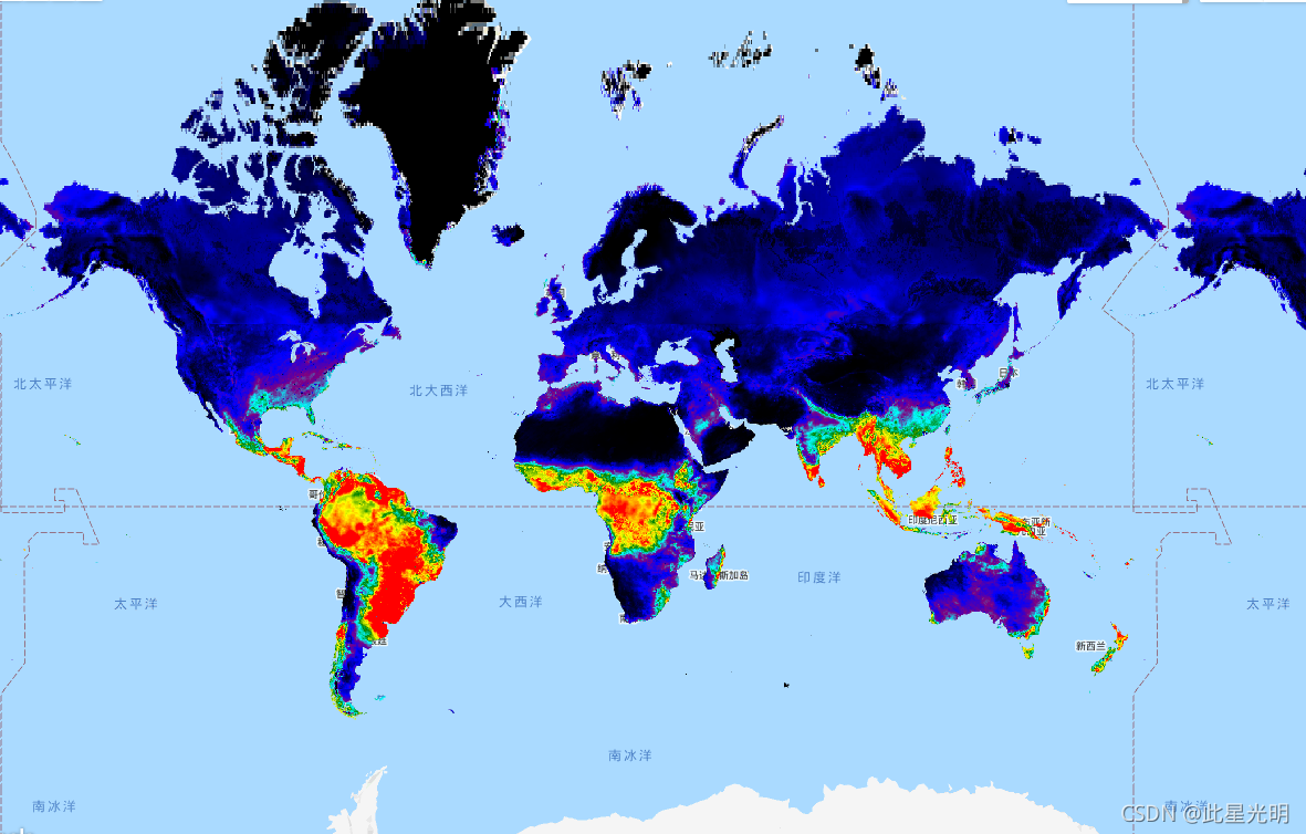
The FLDAS dataset (McNally et al. 2017), was designed to assist with food security assessments in data-sparse, developing country settings. It includes information on many climate-related variables including moisture content, humidity, evapotranspiration, average soil temperature, total precipitation rate, etc.
There are multiple different FLDAS datasets; this one uses Noah version 3.6.1 surface model with CHIRPS-6 hourly rainfall that has been downscaled using the NASA Land Surface Data Toolkit. which is part of the [Land Information System framework](LIS; Software Suite | LIS Framework). Temporal desegregation is required so that daily rainfall inputs can be used in both energy and water balance calculations
For forcing data, this simulation uses a combination of the new version of Modern-Era Retrospective analysis for Research and Applications version 2 (MERRA-2) data and Climate Hazards Group InfraRed Precipitation with Station data (CHIRPS), a quasi-global rainfall dataset designed for seasonal drought monitoring and trend analysis (Funk et al., 2015).
Documentation:
FLDAS数据集(McNally等人,2017年),旨在协助数据稀少的发展中国家的粮食安全评估。它包括许多气候相关变量的信息,包括含水量、湿度、蒸发量、平均土壤温度、总降水率等。
有多个不同的FLDAS数据集;这个数据集使用Noah 3.6.1版本的地表模型和CHIRPS-6小时降雨量,该模型已使用NASA地表数据工具箱进行了降尺度处理。它是[土地信息系统框架](LIS;https://lis.gsfc.nasa.gov/)的一部分。需要进行时间上的分离,以便在能量和水平衡计算中使用每日降雨量输入。
对于强迫数据,本模拟使用了新版本的研究与应用的现代时代回顾分析第2版(MERRA-2)数据和气候危害小组红外降水与站数据(CHIRPS)的组合,这是一个准全球降水数据集,设计用于季节性干旱监测和趋势分析(Funk等人,2015)。
Dataset Availability
1982-01-01T00:00:00 - 2021-08-01T00:00:00
Dataset Provider
NASA GES DISC at NASA Goddard Space Flight Center
Collection Snippet
ee.ImageCollection("NASA/FLDAS/NOAH01/C/GL/M/V001")
Resolution
11132 meters
Bands Table
| Name | Description | Units |
| Evap_tavg | Evapotranspiration | kg m-2 s-1 |
| LWdown_f_tavg | Downward longwave radiation flux | W m-2 |
| Lwnet_tavg | Net longwave radiation flux | W m-2 |
| Psurf_f_tavg | Surface pressure | Pa |
| Qair_f_tavg | Specific humidity | kg kg-1 |
| Qg_tavg | Soil heat flux | W m-2 |
| Qh_tavg | Sensible heat net flux | W m-2 |
| Qle_tavg | Latent heat net flux | W m-2 |
| Qs_tavg | Storm surface runoff | kg m-2 s-1 |
| Qsb_tavg | Baseflow-groundwater runoff | kg m-2 s-1 |
| RadT_tavg | Surface radiative temperature | K |
| Rainf_f_tavg | Total precipitation rate | kg m-2 s-1 |
| SnowCover_inst | Snow cover fraction | |
| SnowDepth_inst | Snow depth | m |
| Snowf_tavg | Snowfall rate | kg m-2 s-1 |
| SoilMoi00_10cm_tavg | Soil moisture (0 - 10 cm underground) | m^3 m-3 |
| SoilMoi10_40cm_tavg | Soil moisture (10 - 40 cm underground) | m^3 m-3 |
| SoilMoi100_200cm_tavg | Soil moisture (100 - 200 cm underground) | m^3 m-3 |
| SoilMoi40_100cm_tavg | Soil moisture (40 - 100 cm underground) | m^3 m-3 |
| SoilTemp00_10cm_tavg | Soil temperature (0 - 10 cm underground) | K |
| SoilTemp10_40cm_tavg | Soil temperature (10 - 40 cm underground) | K |
| SoilTemp100_200cm_tavg | Soil temperature (100 - 200 cm underground) | K |
| SoilTemp40_100cm_tavg | Soil temperature (40 - 100 cm underground) | K |
| SWdown_f_tavg | Surface downward shortwave radiation | W m-2 |
| SWE_inst | Snow water equivalent | kg m-2 |
| Swnet_tavg | Net shortwave radiation flux | W m-2 |
| Tair_f_tavg | Near surface air temperature | K |
| Wind_f_tavg | Near surface wind speed | m s-1 |
使用说明:
Distribution of data from the Goddard Earth Sciences Data and Information Services Center (GES DISC) is funded by NASA's Science Mission Directorate (SMD). Consistent with NASA Earth Science Data and Information Policy, data from the GES DISC archive are available free to the user community. For more information visit the GES DISC Data Policy page.
引用:
If you use these data in your research or applications, please include a reference in your publication(s) similar to the following example: Amy McNally NASA/GSFC/HSL (2018), FLDAS Noah Land Surface Model L4 Global Monthly 0.1 x 0.1 degree (MERRA-2 and CHIRPS), Greenbelt, MD, USA, Goddard Earth Sciences Data and Information Services Center (GES DISC), Accessed: [Data Access Date], doi:10.5067/5NHC22T9375G
McNally, A., Arsenault, K., Kumar, S., Shukla, S., Peterson, P., Wang, S., Funk, C., Peters-Lidard, C.D., & Verdin, J. P. (2017). A land data assimilation system for sub-Saharan Africa food and water security applications. Scientific Data, 4, 170012.
如果你在你的研究或应用中使用这些数据,请在你的出版物中包括类似于以下例子的参考。Amy McNally NASA/GSFC/HSL (2018), FLDAS Noah Land Surface Model L4 Global Monthly 0.1 x 0.1 degree (MERRA-2 and CHIRPS), Greenbelt, MD, USA, Goddard Earth Sciences Data and Information Services Center(GES DISC), Accessed: [数据访问日期], doi:10.5067/5NHC22T9375G
McNally, A., Arsenault, K., Kumar, S., Shukla, S., Peterson, P., Wang, S., Funk, C., Peters-Lidard, C.D., & Verdin, J. P. (2017). 用于撒哈拉以南非洲粮食和水安全应用的土地数据同化系统。科学数据,4, 170012。
代码:
var dataset=ee.ImageCollection('NASA/FLDAS/NOAH01/C/GL/M/V001')
              .filter(ee.Filter.date('2018-11-01', '2018-12-01'));
var layer = dataset.select('Evap_tavg');
var band_viz = {
  min: 0.0,
  max: 0.00005,
  opacity: 1.0,
  palette: ["black", "blue", "purple", "cyan", "green", "yellow", "red"]
};
Map.setCenter(30.0, 30.0, 2);
Map.addLayer(layer, band_viz, 'Average Evapotranspiration');