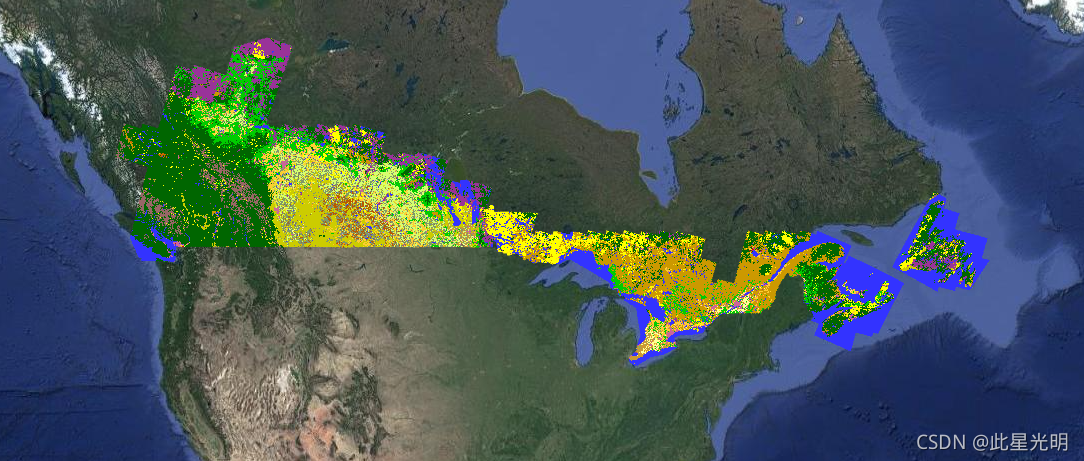
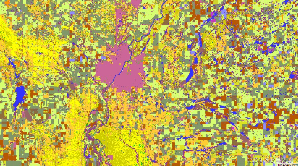
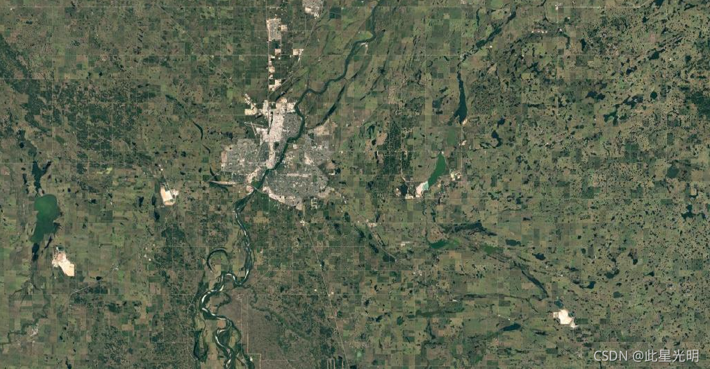
Starting in 2009, the Earth Observation Team of the Science and Technology Branch (STB) at Agriculture and Agri-Food Canada (AAFC) began the process of generating annual crop type digital maps. Focusing on the Prairie Provinces in 2009 and 2010, a Decision Tree (DT) based methodology was applied using optical (Landsat-5, AWiFS, DMC) and radar (Radarsat-2) based satellite images. Beginning with the 2011 growing season, this activity has been extended to other provinces in support of a national crop inventory. To date this approach can consistently deliver a crop inventory that meets the overall target accuracy of at least 85% at a final spatial resolution of 30m (56m in 2009 and 2010).
从 2009 年开始,加拿大农业和农业食品部 (AAFC) 科技部 (STB) 的地球观测团队开始了生成一年生作物类型数字地图的过程。 2009 年和 2010 年以草原省份为重点,使用基于光学(Landsat-5、AWiFS、DMC)和雷达(Radarsat-2)的卫星图像应用了基于决策树 (DT) 的方法。从 2011 年的生长季节开始,这项活动已扩展到其他省份,以支持国家作物清单。迄今为止,这种方法可以始终如一地提供在最终空间分辨率为 30m(2009 年和 2010 年为 56m)时满足至少 85% 总体目标精度的作物清单。
Resolution
30 meters
Bands Table
| Name | Description | Min | Max |
| landcover | Main crop-specific land cover classification. | 1 | 255 |
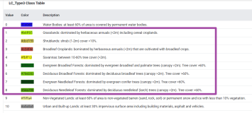
Class Table: landcover
| Value | Color | Color Value | Description |
| 10 | #000000 | Cloud | |
| 20 | #3333ff | Water | |
| 30 | #996666 | Exposed Land and Barren | |
| 34 | #cc6699 | Urban and Developed | |
| 35 | #e1e1e1 | Greenhouses | |
| 50 | #ffff00 | Shrubland | |
| 80 | #993399 | Wetland | |
| 85 | #501b50 | Peatland | |
| 110 | #cccc00 | Grassland | |
| 120 | #cc6600 | Agriculture (undifferentiated) | |
| 122 | #ffcc33 | Pasture and Forages | |
| 130 | #7899f6 | Too Wet to be Seeded | |
| 131 | #ff9900 | Fallow | |
| 132 | #660000 | Cereals | |
| 133 | #dae31d | Barley | |
| 134 | #d6cc00 | Other Grains | |
| 135 | #d2db25 | Millet | |
| 136 | #d1d52b | Oats | |
| 137 | #cace32 | Rye | |
| 138 | #c3c63a | Spelt | |
| 139 | #b9bc44 | Triticale | |
| 140 | #a7b34d | Wheat | |
| 141 | #b9c64e | Switchgrass | |
| 142 | #999900 | Quinoa | |
| 142 | #999900 | Sorghum | |
| 145 | #92a55b | Winter Wheat | |
| 146 | #809769 | Spring Wheat | |
| 147 | #ffff99 | Corn | |
| 148 | #98887c | Tobacco | |
| 149 | #799b93 | Ginseng | |
| 150 | #5ea263 | Oilseeds | |
| 151 | #52ae77 | Borage | |
| 152 | #41bf7a | Camelina | |
| 153 | #d6ff70 | Canola and Rapeseed | |
| 154 | #8c8cff | Flaxseed | |
| 155 | #d6cc00 | Mustard | |
| 156 | #ff7f00 | Safflower | |
| 157 | #315491 | Sunflower | |
| 158 | #cc9933 | Soybeans | |
| 160 | #896e43 | Pulses | |
| 161 | #996633 | Other Pulses | |
| 162 | #8f6c3d | Peas | |
| 163 | #b6a472 | Chickpeas | |
| 167 | #82654a | Beans | |
| 168 | #a39069 | Fababeans | |
| 174 | #b85900 | Lentils | |
| 175 | #b74b15 | Vegetables | |
| 176 | #ff8a8a | Tomatoes | |
| 177 | #ffcccc | Potatoes | |
| 178 | #6f55ca | Sugarbeets | |
| 179 | #ffccff | Other Vegetables | |
| 180 | #dc5424 | Fruits | |
| 181 | #d05a30 | Berries | |
| 182 | #d20000 | Blueberry | |
| 183 | #cc0000 | Cranberry | |
| 185 | #dc3200 | Other Berry | |
| 188 | #ff6666 | Orchards | |
| 189 | #c5453b | Other Fruits | |
| 190 | #7442bd | Vineyards | |
| 191 | #ffcccc | Hops | |
| 192 | #b5fb05 | Sod | |
| 193 | #ccff05 | Herbs | |
| 194 | #07f98c | Nursery | |
| 195 | #00ffcc | Buckwheat | |
| 196 | #cc33cc | Canaryseed | |
| 197 | #8e7672 | Hemp | |
| 198 | #b1954f | Vetch | |
| 199 | #749a66 | Other Crops | |
| 200 | #009900 | Forest (undifferentiated) | |
| 210 | #006600 | Coniferous | |
| 220 | #00cc00 | Broadleaf | |
| 230 | #cc9900 | Mixedwood |
影像属性:
| Name | Type | Description |
| landcover_class_names | List of Strings | Array of cropland landcover classification names. |
| landcover_class_palette | List of Strings | Array of hex code color strings used for the classification palette. |
| landcover_class_values | List of Ints | Value of the land cover classification. |
引用:
Dataset Availability
2009-01-01T00:00:00 - 2019-01-01T00:00:00
Dataset Provider
Agriculture and Agri-Food Canada
Collection Snippet
ee.ImageCollection("AAFC/ACI")
Agriculture and Agri-Food Canada Annual Crop Inventory. {YEAR}
数据代码:
var dataset = ee.ImageCollection('AAFC/ACI');
var crop2016 = dataset
    .filter(ee.Filter.date('2016-01-01', '2016-12-31'))
    .first();
Map.setCenter(-103.8881, 53.0371, 10);
Map.addLayer(crop2016);
有需要研究加拿大农业生态的同学可以拿走!